


guilhaumard

Patriste
User
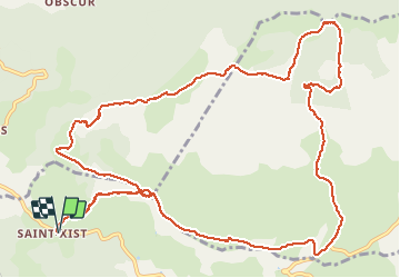

Length
16.1 km

Max alt
841 m

Uphill gradient
354 m
Km-Effort
21 km

Min alt
646 m

Downhill gradient
354 m
Boucle
Yes
Creation date :
2021-05-09 07:38:13.968
Updated on :
2021-05-09 13:39:06.176
5h18
Difficulty : Medium

FREE GPS app for hiking
 SityTrail
IGN / Geographical institutes
SityTrail Plus
The world is yours!
About
Trail Walking of 16.1 km to be discovered at Occitania, Aveyron, Le Clapier. This trail is proposed by Patriste.
Photos


Positioning
Country:
France
Region :
Occitania
Department/Province :
Aveyron
Municipality :
Le Clapier
Location:
Unknown
Start:(Dec)
Start:(UTM)
510738 ; 4854234 (31T) N.
Comments